
First Century Harbors on the Sea of Galilee
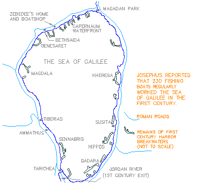
The Sea of Galilee: Newly Discovered Harbors From New Testament Days
Taken from work by Mendel Nun, Kibbutz Ein Gev, Israel
Ever since man first settled on the shores of the Sea of Galilee, it has been used for fishing, and later also for transport. During the prosperous period of the early Christian era, under Roman rule as described by Josephus, hundreds of vessels plied the waters. The Sea of Galilee is 21 kilometers long, 12 kilomers across, and reaches a maximum depth of 44 meters. The surface is 170 square kilometers, and the drive around the lake covers 65 kilometers.
It has always been known for sudden storms, and in rough weather, crews needed safe moorings. But except for a few inlets to the north of the lake, there are no natural harbours, and the earliest fishermen and sailors were obliged to drag their boats to dry ground on the shore. All settlements around the lake were dependent on fishing and maritime transport, and therefore had to build protected mooring places for their boats.
The history of the harbours of the Sea of Galilee has always been closely linked to the history of the settlements around the shore, and to the events that made these settlements famous throughout the world. Most, but not all, of these settlements were founded or rebuilt in the last centuries before the Christian era; and this is probably when the first harbours were built.
Many ruins from Roman times may still be seen around the lake: well planned cities, public buildings and temples, sophisticated hydraulic engineering facilities, and a network of roads and bridges. The Romans also developed maritime transport, and were known for the superior construction of their harbours. We may therefore assume that the important harbours arond the Sea of Galilee date from this period.
With the gradual economic and cultural decline which followed the Arab conquest, most maritime transport facilities were neglected. Breakwaters were destroyed by pounding waves, and valuable stone building blocks were removed and reused.
It was not until the 1970's that ancient harbours were first discovered along the lakeshore -- primarily during the low water levels between 1971 and 1991. This has made it possible to "put on the map" some sixteen ancient harbours unknown until recently.
A service of
The Urantia Book Fellowship
Serving the Readership since 1955